TRADERS in Digital Methods Initiative (summer school)
The Digital Methods Summer School (June 23rd until July 4th 2014) was hosted by the University of Amsterdam. Naomi Bueno de Mesquita, TRADERS researcher in multiple performative mapping at Design Academy Eindhoven participated in this summer school. Digital Methods Initiative seeks to learn from the methods built into the devices online, by subtracting the data (links, tags, threads, etc) and repurposing them for social and cultural research. In this summer school with the topic ‘on geolocation’ the focal point was to analyse events as they unfold, by subtracting geo-located embedded data.
The first project explored how twitter data constructs a narrative of the city of Amsterdam, by analyzing the way people (locals and tourists) tweet about the city. Two data sets (geo-tagged data of Amsterdam and keywords about Amsterdam) of one month were used. Some of the findings: the most frequently used words to describe Amsterdam in Chinese were: creative, incredible and confused. A sudden peek of the word #zwerfie (a selfie taken while picking up trash) emerged in a neighborhood in the west, during the three day strike of garbage services in the city. As for the transportation, some individuals always tweet on the same spot while others commuting. Bus 300 had the most active tweeter. In general the bus or tram stops are more frequently used for tweeting than in the trams or buses. The problems/ limitations of this project: a methodological gap between keyword and geolocation-data analyses and the need to obtain more qualitative data. http://www.slideshare.net/naomibueno/201407-summerschool-dmilivability-in-amsterdam
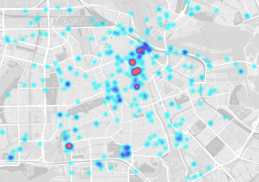
heat map of bus tweets, http://mngroen.nl/dmi/mobility/
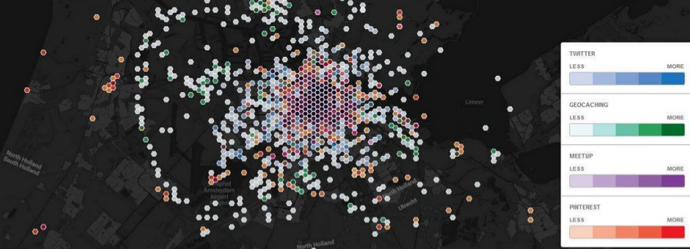
The second week’s project (The City As Interface) was pitched by Martijn de Waal and explored how geosocial media platforms remediate the city. The following question was explored: What kind of Amsterdam do geosocial media platforms (such as Foursquare, Twitter, Pinterest, Flickr, Meetup and Geocaching) present and can we identify the parochial and the public spaces of the city by looking at the places put forward by these platforms? We retrieved Amsterdam-specific posts, meetups, pins, tweets and geocaches and plotted them on a map. Some of the main findings: pinterest produces the ‘boutique view’ of Amsterdam, marking the 9-streets, the Haarlemmerstraat and Haarlemmerdijk, featuring concept stores and smaller bars or restaurants where not the larger commercial ones predominate. Meetup manifests the parochial city, of which each theme (tech, socializing, fitness, career, singels, fine arts, etc) is linked to a different bar. Geocaching, In comparison with other geosocial platforms/ networks, is less of an urban phenomenon. Geocachers are more likely to engage with places that are harder to get to or on the periphery of the city. For future research we would have to rank the places from more public to more parochial, to map per category (cross-platform) and to combine it with a bottom-up approach.
http://www.slideshare.net/naomibueno/digital-methods-the-city-as-interface
http://mmauri.cartodb.com/